Materano Path – Hellenic Way: from Alberobello to Matera in 7 stages
170 km on foot from Alberobello to Matera through trulli, woods, ravines, and rock villages.
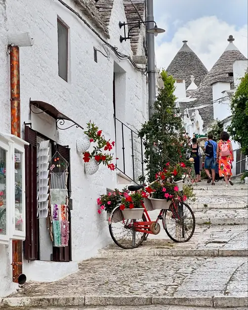
The Via Ellenica is a unique route on the Cammino Materano. It connects two very different UNESCO sites: Alberobello and the Sassi of Matera.
The path crosses the Terra delle Gravine, a scenic area in Puglia. It's known for rocky canyons, cave villages, woods, farms, and towns on the canyon edges.
The entire route is about 170 km, usually split into 7 stages. You walk about 20-22 km daily on average.
Compared to other routes on the Cammino Materano, the Via Ellenica mixes agricultural and rocky landscapes.
Sometimes you walk among olive trees, farms, and open fields. Other times, deep rocky gorges, cave churches, and canyons suddenly appear, changing the view completely.
Main stops include:
Alberobello
Martina Franca
Crispiano
Massafra
Mottola
Palagianello
Castellaneta
Laterza
Ginosa
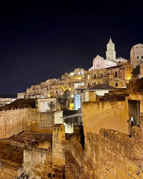
Matera
There are many places along the way. Sometimes, a single stage connects multiple villages or canyon systems in one day.
Alberobello - Martina Franca
Average distance: about 16-18 km
Average time: 4-5 hours
Difficulty: medium-easy
The Via Ellenica starts with one of Puglia's most recognizable sections.
Leaving Alberobello, you immediately pass through the Monti district. This historic trulli area is a UNESCO heritage site.
The first kilometers lead to the Bosco Selva Oasis, introducing the typical landscape of the Itria Valley.
After the woods, the path continues through rural trails and roads bordered by dry stone walls, also UNESCO heritage.
The landscape constantly alternates between olive groves, oak woods, trulli, and farms. It creates one of the most scenic starts of the entire Cammino Materano.
Unlike other routes focused on canyons and rocky settings, here the agricultural landscape of the Itria Valley dominates.
Arriving in Martina Franca changes the atmosphere. The baroque historic center introduces a very different urban feel compared to the rural start.
Martina Franca - Crispiano
Average distance: about 20-22 km
Average time: 5-6 hours
Difficulty: medium
This stage crosses some of the most interesting wooded areas of the Via Ellenica.
After Martina Franca, the path enters the Murge Orientali Nature Reserve.
For several kilometers, you walk in the silence of woods, among oaks, limestone outcrops, clearings, and typical Mediterranean vegetation.
Along the way, you also find Masseria Gorgofreddo, linked to Murgese horse breeding.
The second part of the stage crosses the Bosco delle Pianelle, one of Puglia's largest green lungs.
The forest lies within a large karst sinkhole. The path crosses about 7 km of a large holm oak forest with monumental trees.
Compared to the first stage in the Itria Valley, the environment here becomes wilder and less agricultural.
Arriving in Crispiano also marks the symbolic transition from the Itria Valley to the Terra delle Gravine.
Crispiano - Massafra
Average distance: about 20 km
Average time: 5-6 hours
Difficulty: medium
From Crispiano, the path enters the Terra delle Gravine, a unique natural area in Puglia.
The first kilometers cross the Gravina di Triglie, following paths along the riverbed amid Mediterranean vegetation, rocky walls, and traces of ancient cave settlements.
Along this stretch, you also find cave dwellings and the rock churches of San Cipriano and San Michele.
Compared to previous stages, here the agricultural areas of the Itria Valley give way to the karst canyons typical of the Terra delle Gravine.
The path then continues towards Masseria Amastuola, an ancient farm surrounded by a large vineyard-garden designed by landscape architect Fernando Caruncho.
Arriving in Massafra introduces one of the centers most connected to the rock culture of the entire Ionian area of Puglia.
Massafra - Mottola
Average distance: about 22-24 km
Average time: 6-7 hours
Difficulty: medium
Leaving Massafra, you cross one of Puglia's most important rock landscapes.
The city is known for its canyons, caves, and underground environments that show centuries of rock life.
Massafra lies between the Gravina di San Marco and the Madonna della Scala, two deep canyons filled with caves and ancient settlements.
After leaving the city, the path continues along trails among ancient olive trees and gradually climbs in altitude.
One of the most picturesque sections leads to the Bosco di Sant'Antuono, crossed by ancient trails and panoramic paths.
Compared to previous stages, here the landscape constantly alternates between canyons, woods, and open views towards the Ionian arc.
Arriving in Mottola concludes one of the most panoramic stages of the Via Ellenica.
Mottola - Palagianello - Castellaneta
This stage connects three different towns in one day. The distances between Palagianello and Castellaneta are short. The route follows the gravine system without urban breaks.
Average distance: about 20-22 km
Average time: 5-6 hours
Difficulty: medium
The descent from Mottola uses ancient paths. These lead to one of the most important rock areas of the stage.
Along the way, you find the Casalrotto rock village. It's made of many caves along the gravine's sides. There's also the Sant'Angelo rock church, unique for its two levels.
Soon after, you see the San Nicola rock church. It's one of the most interesting examples of medieval Apulian sacred art.
The route continues to Palagianello, offering panoramic views between the historic center and the gravine bed.
The final part leads to Castellaneta. It follows paths along the edge of the namesake gravine, one of Puglia's largest and most spectacular.
This stage is closely tied to the area's rock dimension. It's probably one of the most scenic of the entire Via Ellenica.
Castellaneta - Laterza
Average distance: about 22-24 km
Average time: 6-7 hours
Difficulty: medium
This is probably one of the most spectacular stages of the Via Ellenica.
You leave Castellaneta, crossing olive groves and rural roads. These lead to the Montecamplo nature reserve.
Here, the landscape turns into a dense forest. It's filled with fragni, roverelle, holm oaks, spiny oaks, and Aleppo pines.
These areas were hideouts for many 19th-century bandits. The land still holds many stories from that time.
The route then climbs gradually, offering wide views. On clear days, you can see the Gulf of Taranto, Basilicata, and even the Calabrian hills.
One of the most impressive parts is the final stretch. The path runs for several kilometers along the edge of the Gravina di Laterza.
With walls over 200 meters high, the gravina is one of Europe's largest canyons. It's also one of the most spectacular natural settings of the entire walk.
The last part crosses the Lipu Oasis before arriving in Laterza.
This stage constantly alternates between woods, Mediterranean scrub, open views, and rock environments. It summarizes many typical landscapes of the Via Ellenica.
Laterza - Ginosa - Matera
Average distance: about 28-30 km
Average time: 7-8 hours
Difficulty: challenging
The last stage crosses some of the wildest and most symbolic landscapes of the Via Ellenica.
From Laterza, the route continues along country roads among olive trees. It reaches the Murgia San Pellegrino pine forest, historically crossed by shepherds during transhumance between Basilicata and the Ionian plains.
After the rural Apulian area, the path enters the Lucanian hills. These are characterized by crops, olive groves, and wide open views.
In this section, it's common to see birds of prey soaring above, accompanying travelers for much of the stage.
In the second part, you walk for several kilometers along paths near the Gravina di Matera. It's one of the most famous rock canyons in southern Italy.
From above, cave houses, rocky walls, and ancient rock environments gradually appear. They signal the approach to the Sassi.
The final entry into Matera is through the Casalnuovo district.
A narrow passage carved into the rock suddenly reveals the Sassi. It's a natural and scenic conclusion to the entire journey.
After several days immersed in the Land of the Gravine, arriving in Matera is probably one of the most powerful moments of the Via Ellenica.
The Via Ellenica doesn't have particular technical difficulties. But some stages can become challenging, especially in hot months.
The main difficulties usually come from:
the length of some stages;
exposure to the sun;
constant ups and downs near the gravine;
long rural stretches.
The path is well-marked and has a network of accommodations along the way.
The Via Ellenica is complete in terms of signage and accommodation facilities.
This makes the route easier to organize compared to less structured paths.
To officially walk the path, it's advisable to start with the Cammino Materano credential.
You can request the credential through the official website and usually pick it up before starting.
Like other Cammino Materano routes, it's wise to book in advance, especially during busy periods like spring and holiday weekends.
The best periods are generally:
spring;
early autumn.
In summer, some stages can get very hot, especially in the more exposed parts of the Land of the Gravine.
Spring is probably the most balanced time, with milder temperatures and greener rural landscapes.