Rifugio Aosta the ideal destination for mountain lovers
The Aosta Refuge is the ideal destination for mountain excursions.
Where is the Aosta Refuge located in Aosta Valley?
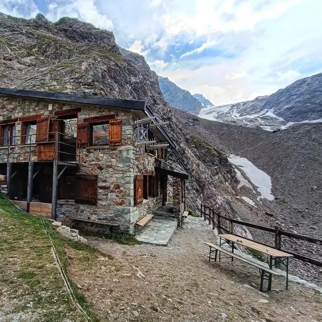
The Aosta Refuge is located at the head of the Valpelline, at an altitude of 2788 meters, on a ridge facing east, right next to the terminal tongue of the Tza de Tzan glacier. It is a wild and fascinating area, immersed in unspoiled alpine nature.
The refuge belongs to the Aosta section of the CAI (Italian Alpine Club) and is managed by the Valconfi cooperative, specialized in the sustainable management of mountain structures.
How do you get to the Aosta Refuge by car and on foot?
To reach the Aosta Refuge, a mix of car travel and mountain trail is necessary. By car: Take the A5 motorway and exit at Aosta Est. Follow the bypass towards the Gran San Bernardo Tunnel until Variney. From there, continue on the Regional Road 18 towards Valpelline and then towards Bionaz. Just before the town of Bionaz, turn left towards the Place Moulin dam (2000 m above sea level). At the dam, you will find two convenient free parking areas.
On foot: You walk for about 1 hour along the dirt road that runs alongside the artificial Place Moulin lake, until you reach the Prarayer locality. From Prarayer, the well-marked trail 10a starts, which takes about 3 hours of ascent to reach the refuge. The last stretch features a short section equipped with chains, but crampons are not necessary due to the glacier's retreat.
What is the elevation gain of the trail to the Aosta Refuge?
From the parking lot at the Place Moulin dam (2000 m) to the Aosta Refuge (2788 m), there is an elevation gain of about 800 meters. The hike is challenging but offers spectacular views of peaks, moraines, and glaciers.
What excursions can be done from the Aosta Refuge?
The Aosta Refuge is a strategic point for various crossings and ascents in the Valpelline. Among the most frequented: Tête de Valpelline, Dent d’Hérens, Col de Collon, for those who want to continue towards Switzerland, and Pointe de Tzan. These excursions are ideal for experienced hikers or climbers looking for less beaten paths.
Is the Aosta Refuge accessible without mountaineering experience?
Yes, the access trail to the Aosta Refuge does not require ice equipment such as crampons or ice axes. The only more technical stretch is the one equipped with chains, but it is short and well marked. However, it is important to be accustomed to walking in the mountains and to have good physical training.
How long does it take to climb to the Aosta Refuge?
From the parking lot at the Place Moulin dam to the refuge, the total travel time is about 4 hours: 1 hour from the parking lot to Prarayer and 3 hours from Prarayer to the refuge, following trail 10a. The route is well marked and crosses landscapes of rare beauty.
Where to park to climb to the Aosta Refuge?
The main parking areas are located at the Place Moulin dam, at about 2000 meters altitude. They are free, spacious, and very frequented by hikers and climbers. From here, the path to Prarayer and then to the refuge begins.
What views does the Aosta Refuge offer?
The view from the Aosta Refuge is dominated by the Tza de Tzan glacier, the peaks of Valpelline, and the mountain range of Monte Rosa in the background. The landscape is wild, spectacular, and perfect for those seeking an authentic high mountain experience.
Is the Aosta Refuge open all year round?
Generally, the Aosta Refuge is open in the summer months, from late June to September, depending on weather conditions and snow cover. For updated openings, it is advisable to contact the CAI Aosta management or the Valconfi cooperative directly.
Why choose the Aosta Refuge for trekking in Valpelline?
The Aosta Refuge is the ideal choice for those seeking panoramic hikes at high altitude, glacial environments accessible without crampons, tranquility, and unspoiled nature. It is a base for alpine climbs and alpine crossings. Located in one of the wildest valleys of Aosta Valley, it is perfect for an authentic mountain experience.