Unmissable hike to Testa di Comagna
Discover the unmissable hike to Testa di Comagna with useful details.
Where does the trail to Testa di Comagna start?
The hike starts from Col de Joux, a pass at 1,640 meters altitude that connects Val d'Ayas with Saint-Vincent. The pass is easily reachable by car from both Brusson and Saint-Vincent via the scenic SR33 road, one of the most beautiful in the Aosta Valley. Once at the pass, you can leave your car in the convenient parking area located near the main square, the starting point for various hiking trails.
How does the path to Testa di Comagna begin?
From the parking lot, take the dirt road prohibited to traffic that leads left into the larch and fir forest. After a few minutes of walking, you can already feel the tranquility of the mountains: the trail climbs gently, shaded and well-marked with the signs of trail no. 1C. The ground is regular and free of difficulties in the first part, making the walk pleasant and relaxing.
How do you proceed along trail no.
1C?
The route of trail no. 1C winds through a silent and fragrant forest, where it is easy to encounter squirrels climbing among the trees and birds singing among the branches. In spring, the undergrowth is colored with alpine flowers, while in autumn the foliage transforms the area into a riot of golden and reddish tones. The path continues gently until the fork with trail no. 1B, which deviates to the right towards Testa di Comagna.
What is the final stretch like towards the summit?
From the fork, the climb becomes more challenging and the path becomes suitable for experienced hikers. The trail narrows and climbs along the slope, alternating between wooded sections and open clearings. The environment becomes wilder and more panoramic: among the clearings, spectacular views open up over Val d'Ayas and the central valley. In some places, you can spot marmots moving among the meadows and, with a bit of luck, eagles soaring in the clear sky.
What is the difficulty of the Col de Joux - Testa di Comagna itinerary?
This is a route classified for experienced hikers (EE). Although it does not present technical passages, it requires good training and adequate equipment: trekking boots, poles, layered clothing, and a supply of water. The total length of the hike is about 8 kilometers (round trip), with a positive elevation gain of about 600 meters. Average travel times vary between 3 and 4 hours, depending on pace and stops.
What can you see along the route?
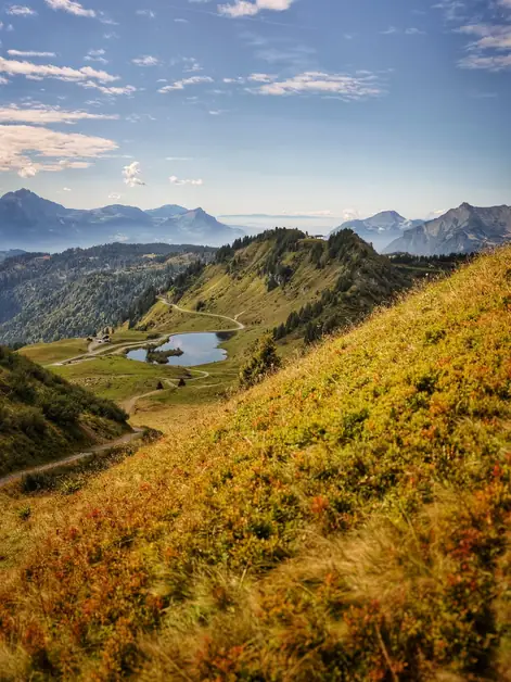
In addition to the beauty of the coniferous forests, the trail offers continuous panoramic views. Half an hour from the arrival, you will encounter a natural viewpoint with benches, perfect for a refreshing break. From here, you can admire a wide view of Brusson, with its lake and the surrounding mountains. The panorama also extends towards Saint-Vincent, up to the Mont Blanc group, which stands majestically on the horizon on the clearest days.
How to recognize local wildlife?
Along the way, it is possible to encounter various animals typical of the Aosta Valley Alps. Squirrels are among the easiest to spot in the early wooded sections, while in more open areas you can see mountain hares or marmots enjoying the sun. High above, it is not uncommon to see golden eagles soaring over the valley in search of prey. For this reason, it is advisable to bring binoculars: observing wildlife in silence is one of the most rewarding experiences of the hike.
What views can be admired from Testa di Comagna?
From the summit, at 2,100 meters altitude, the view is among the most beautiful in the area. To the south, the view opens up over Val d'Ayas, with the villages of Brusson, Challand-Saint-Anselme, and Challand-Saint-Victor nestled among the woods. To the west, you can admire the Mont Blanc chain, while to the east, Mont Avic and Mont Nery are clearly distinguishable. On clear days, the horizon extends to Gran Paradiso and Cervino. It is an exceptional viewpoint for those who love to photograph or simply enjoy the vastness of the alpine landscape.
When is it advisable to tackle the hike?
The ideal period is from June to October, when the trail is free of snow and the days are long. In spring, the meadows fill with flowers and the weather is cool, while in autumn the warm sunlight gives spectacular tones to the woods. During the summer, temperatures remain pleasant even during the hottest hours of the day thanks to the altitude. In winter months, the path may be covered with snow or ice and is suitable only for those with experience with snowshoes or crampons. In case of doubt, it is always better to inquire at the tourist offices in Brusson or Saint-Vincent.
Useful tips before leaving
Wear mountain boots with good grip. Bring telescopic poles to facilitate the ascent and descent. Always carry water and some energy snacks. Avoid the hottest hours of the day, especially in summer. Check the weather forecast and only leave with stable weather.