Trail Running Route Blending History and Nature
A trail running route that blends history and nature, ideal for hikers and tourists.
What is the trail running route from the Military Shrine of Pocol to the Belvedere?
The trail running route connecting the Military Shrine of Pocol to the Belvedere is one of the most fascinating itineraries in the Cortina d'Ampezzo area. It is a path that combines nature, history, and unique views, perfect for those who love running in the mountains but also for those who wish to walk slowly discovering the Ampezzo basin.
This itinerary crosses some of the most characteristic places in the Tofane area, allowing you to observe Cortina from unusual and charming perspectives. The combination of woods, historic villages, memories of World War I, and scenic viewpoints makes the route ideal for tourists and hikers.
The trail starts from the center of Cortina and develops between inhabited areas, forest paths, and places of great historical value. It is an accessible route of medium difficulty, suitable for those who want to experience the mountains authentically.
Where does the trail running itinerary start and how do you reach Crignes and Melères?
The itinerary begins in the center of Cortina d'Ampezzo. From here, you need to head towards the Lungo Boite bridge and cross it, following the road that runs alongside the stream. Before the parking lot on the left, you take the steep road on the right.
This climb leads directly to the village of Crignes, a fascinating place that preserves traditional Ampezzan architecture. Walking or running among these wooden and stone houses, you can imagine the life of the past, filled with agricultural activities and mountain rhythms.
Continuing, the road forks: choosing the branch on the right leads to the locality of Melères, one of the best-preserved villages in the entire valley. The historic houses, tabià, and small glimpses of the landscape make this stretch particularly picturesque.
Once you have crossed Melères, the route leads to the State Road 48 of the Dolomites. After crossing it, you enter the village of Lacedel, where the ski slopes of the Socrepes area are located.
What trails do you take and what can you admire in the Pocol and Tofane area?
After reaching Lacedel, on the right is the Baby Chairlift of Socrepes, while on the left begins trail n° 403, marking the entrance to the most naturalistic part of the itinerary.
The trail develops in the woods and runs alongside the Pocol area, offering glimpses of the Tofane slopes. This stretch is perfect for those looking for a shaded path, with gentle climbs and a serene environment.
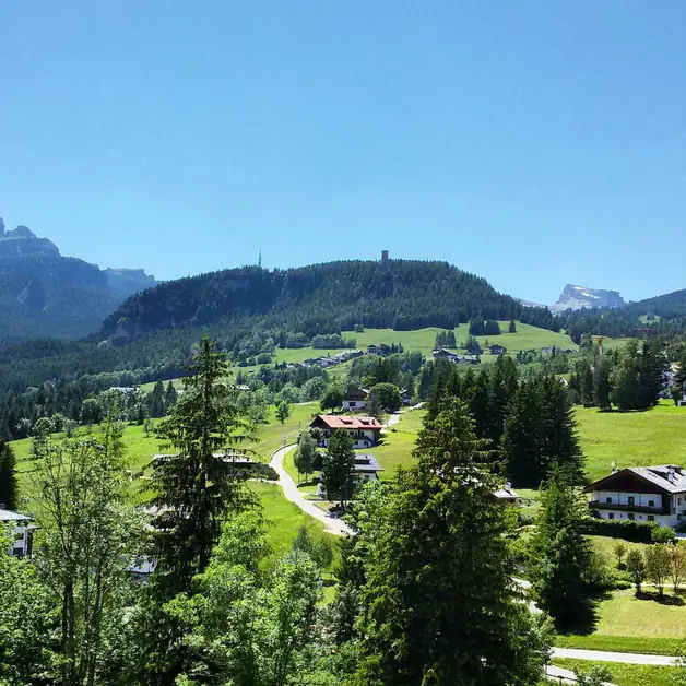
Nature is the protagonist here: the scent of larches, mountain silences, and plays of light among the trees. The panoramas open up at times, allowing you to observe Cortina from above and recognize the first lines of the Dolomites.
The trail crosses an area much loved by winter sports enthusiasts, but walking it in summer or autumn allows you to discover a more intimate and tranquil side of the mountain.
Why is the Military Shrine of Pocol an important stop on the route?
The trail leads to the Military Shrine of Pocol, one of the most significant places of historical memory in Ampezzo. Here rest the fallen of World War I from various cemeteries in the valley.
Among the personalities buried in the Shrine are General Antonio Cantore and Lieutenant Francesco Barbieri, very important figures in the history of the Dolomite front.
The place is solemn and panoramic, overlooking the Ampezzo basin and surrounded by the silence of the woods. From the Shrine, you take trail n° 429, located on the left and well-marked.
This stretch of the route is particularly moving because it combines history, nature, and a strong sense of respect for the events that marked the valley.
How do you reach the Belvedere and what can you see along the way?
Continuing on trail n° 429, you enter a stretch immersed in the woods, where the descent is constant but never too demanding. Nature here is lush, and the trail offers small scenic glimpses that anticipate the arrival at the Belvedere.
The Belvedere is one of the most well-known viewpoints in the entire area. From here, you can admire the Ampezzo Basin in all its extent, with the profile of the Tofane, the center of Cortina, and the surrounding mountains.
It is a perfect place for a break, to take photographs, or simply to observe the scenery. From this point, you can appreciate the great variety of landscapes that characterize Cortina: woods, meadows, rocky peaks, and valleys.
The descent continues along trail n° 429, which intersects State Road 48. The route is interrupted for a few meters, but it is enough to briefly climb the road to re-enter the trail.
How does the return to Cortina d'Ampezzo take place along trails 429 and 428?
After resuming the trail, the route continues until the point where trail n° 429 naturally joins trail n° 428.
From here, you reach the locality of Mortisa, a quiet and panoramic area located above Cortina. The route is pleasant, with an alternation of short stretches in the woods and openings over the valley.
The descent towards the center of Cortina is simple and smooth, suitable even for those who decide to walk the itinerary without running. Mortisa is a very picturesque spot from which you can observe the Ampezzo basin from a different angle compared to the usual viewpoints.
The trail ends in the heart of Cortina, after a complete route that combines sport, history, and nature.
The trail offers a variety of environments ideal for those who love trail running, for those who want to explore the Ampezzan villages, and for those who wish to learn about the historical places linked to World War I.